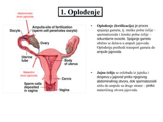
Geonauka
Vol. 1, No. 1 (2013)
13
INSPIRE as a support for development of spatial units valuation
Hrvoje TOMI
Ć
1*
, Siniša MASTELI
Ć
IVI
Ć
1
, Miodrag ROI
Ć
1
1 University of Zagreb, Faculty of Geodesy, Zagreb, Croatia
Abstract. The traditional division of official spatial information registers among several administrative bodies which
manage them disables their quality and timely insight in spatial state. The establishment of modern automatic
valuation systems enables more effective spatial management. In order for these systems to work, certain conditions
have to be met. Spatial information is complex information which needs to be carefully modelled and by managing
them in a digital form greater interoperability will be enabled. That enables the production of subsystems which use
the information of the existing registers. In that way the system of mass real estate valuation would be based on
official information of space information registers managed on national level. That would, with the help of familiar
and clear methodology, through calculation transparency guarantee the justice of values determined by the system.
The unambiguousness and adaptability of spatial information towards the systems of automatic management and
information processing is best reached by application of certain norms. The infrastructure of spatial information
prescribes those norms and gives guidelines for the development and improvement of spatial information. The
infrastructure of spatial information in Croatia is supported by and prescribed through several laws, and all of them
are in accordance with European directive for infrastructure of spatial information – INSPIRE. INSPIRE, among
other things, has the goal to enable the exchange of information among different subjects and enable free combining
of spatial information from different sources in whole Europe. The paper describes the combination of various sorts
and sets of information of transport network which will, according to INSPIRE, be made within the national
infrastructure of spatial information, and which will be used as factors of real estate valuation.
Keywords: mass real estate valuation, administrative boundaries, SDI
INSPIRE kao podrška razvoju vrednosti prostornih jedinica
Apstrakt. Tradicionalna podela zvani
č
nih registara prostornih informacija izme
đ
u više organa uprave, koji upravljaju
njima, onemogu
ć
ava njihov kvalitet i pravovremen uvid u stanje u prostoru. Uspostavljanje savremenih automatskih
sistema procene vrednosti nepokretnosti omogu
ć
ava efikasnije upravljanje prostorom. Da bi ovi sistemi mogli da rade
moraju biti ispunjeni neki uslovi. Prostorna informacija je kompleksna informacija koja treba da se pažljivo modelira
i da se njom pažljivo upravlja u digitalnom obliku kako bi se omogu
ć
ila bolja interoperabilnost. To omogu
ć
ava
uspostavljanje podsistema koji koriste informacije postoje
ć
ih registara. Na taj na
č
in sistem masovne procene
vrednosti nepokretnosti bi mogao biti baziran na podacima zvani
č
nih prostornih registara kojim se upravlja na
nacionalnom nivou. To bi, uz pomo
ć
poznate i jasne metodologije, kroz transparentnost obra
č
unavanja garantovalo
pravi
č
nost vrednosti odre
đ
enih sistemom. Nedvosmislenost i prilagodljivost prostornih informacija prema sistemima
automatskog upravljanja i obrade informacija je najbolje posti
ć
i primenom odre
đ
enih normi. Infrastruktura prostornih
podataka propisuje ove norme i daje smernice za razvoj i unapre
đ
enje prostronih informacija. Infrastruktura
prostornih podataka u Hrvatskoj je podržana i propisana kroz nekoliko zakona, a svi su u skladu sa evropskom
direktivom za infrastrukturu prostornih informacija – INSPIRE. INSPIRE, izme
đ
u ostalog, ima za cilj da omogu
ć
i
razmenu informacija izme
đ
u razli
č
itih subjekata i omogu
ć
i slobodno kombinovanje prostornih podataka iz razli
č
itih
izvora u celoj Evropi. U radu je opisana kombinacija razli
č
itih vrsta i skupova informacijasaobra
ć
ajne mreže koja
ć
e,
u skladu sa INSPIRE, biti napravljena u okviru nacionalne infrastructure prostornih podataka, a koja
ć
e se koristiti
kao factor procene vrednosti nekretnine.
Klju
č
ne re
č
i: masovna procena vrednosti nepokretnosti, administrativne granice, SDI
*
Hrvoje Tomi
ć
> [email protected]
Geonauka
Vol. 1, No. 1 (2013)
14
1
Introduction
Although
the
fundamental
reason
for
the
establishment of the majority of cadastral systems is real
estate taxation, in Croatia the determination of the
amount of the real estate tax based on the cadastral
income was abandoned in 2001 according to the Law on
State Survey and Real Estate Cadastre in that time. [1]
The abolishment of the system and the methods of
cadastral classification signified the abolishment of the
only system of agricultural land valuation on a national
level.
The establishment of modern automatic systems of
mass real estate valuation enables more effective spatial
management of a country, as a limited and valuable
resource. Those systems can and are used for several
purposes, for example: just taxation of real estate
property, help in real estate market, and help in
managing rural and urban land.
In order to regulate spatial relations according to
modern technological findings, it is necessary to enable
all necessary preconditions – integration of the attributes
connected to space, which are traditionally divided
among several administrative bodies. The majority of
modern valuation systems are based on cadastral
information as the basic information layer. The effective
functioning of real estate cadastre, as the fundamental
infrastructural system [2], helped by SDBMS (Spatial
Database Management System) or GIS technologies,
makes the procedure of planning and realization of
economic and other activities connected to real estate
easy, but it also makes real and justifiable goals of
spatial development [3].
Real estate valuation is a complex procedure and it
most often includes multicriteria valuation based on
spatial information stored and divided among several
administrative bodies. Without clear norms which define
the procedures of collecting, maintaining and formation
of metadata – information about information, it is rather
difficult and hardly possible to unite all the above
mentioned information about space and to use them in
the systems of real estate valuation. The current Law on
State Survey and the Real Property Cadastre from 2007
[4], among other things, gives a definition of National
Spatial Data Infrastructure. In that way it establishes the
goals of the making and improving the national
infrastructure of spatial data. All articles of the above
mentioned law are in compliance with the INSPIRE
directive
–
European
initiative
for
improving
infrastructure of spatial data on a regional level. The
goal of the above mentioned initiative is to establish and
improve the infrastructure of spatial data on a European
level, and the establishment of the norm sets of data with
accompanying metadata, as well as discovery services
and dissemination of data.
By joining the EU, Croatia will, along with
challenges such as restoring land registers and keeping
real estate cadastre up-to-date to the state on the field, be
obliged to make the sets of spatial data according to
INSPIRE directive [5]. That will enable the making of
the mass real estate valuation system by using the
existing sets of spatial data. One of more important
factors of real estate valuation are transport networks,
for which the metadata should have been prepared, and
the complete harmonization and the preparation of
transport network data should be done by 2017 at the
latest [10].
2 Background and Methods
In most European countries there is a certain model of
real estate valuation that evaluates some of the physical
characteristics of real estates, i.e. cadastral parcels with
accompanying building and other constructions. The
mentioned systems evaluate the real estate value by
dividing them on agricultural and buildable cadastral
parcels (built or non-built), which are mostly taxed
jointly with one tax on a real estate. The evaluation of
agricultural land takes into consideration agricultural
abilities of the land: the quality of the soil, the water
regime, the elevation and climate influence and
economic conditions for production – infrastructure and
alike. For built and non-built land one of the three
valuation methods: Cost Approach, Sales Comparison
Approach and Income Capitalization Approach.
2.1 Real estate valuation methods
Real estate valuation assessment is the prediction of
the real estate value based on experience, and the
valuation of its spatial and other features. It inevitably
includes dependence on market factors. The mentioned
methods are mainly used for individual assessments of
the value of non-built or built buildable land. They
include the appraiser, which makes the procedure longer
and more expensive, and enable the dependence of the
appraised value on the subjective impression of the
appraiser.
Mass valuation is a procedure which, based on the
objective factors, appraises the value of a large number
of real estate by statistic methods. In order for the
appraised value to be just and correct, it is necessary to
have enough information on each real estate. It is
possible, with limited certainty, to predict the value of a
certain factor used in the further procedure of the
calculation of the final value [6],[7], i.e. appraised value
got based on mass valuation information, taking into
consideration market factors, by statistical methods.
Valuation appraisal of things is strictly monetary,
and its function will be the measure of value and price
[8]. Depending on the purpose and on the used method,
the determination of the real estate value is a complex
procedure that involves quantitative valuation of
qualitative factors of a real estate. By implementing
market factors in the calculation, we can talk about